


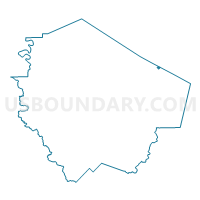
Voting District 2070, Fort Bend County, Texas
About
Outline

Summary
| Unique Area Identifier | 673212 |
| Name | Voting District 2070 |
| County | Fort Bend County |
| State | Texas |
| Area (square miles) | 0.18 |
| Land Area (square miles) | 0.18 |
| Water Area (square miles) | 0.00 |
| % of Land Area | 100.00 |
| % of Water Area | 0.00 |
| Latitude of the Internal Point | 29.63116100 |
| Longtitude of the Internal Point | -95.54236600 |
Maps

Graphs
Select a template below for downloading or customizing gragh for Voting District 2070, Fort Bend County, Texas


Neighbors
Neighoring Voting District (by Name) Neighboring Voting District on the Map
- Voting District 0506, Harris County, TX
- Voting District 2027, Fort Bend County, TX
- Voting District 2081, Fort Bend County, TX
- Voting District 2140, Fort Bend County, TX
Top 10 Neighboring County Subdivision (by Population) Neighboring County Subdivision on the Map
- Houston CCD, Harris County, TX (3,075,388)
- Stafford-Missouri City CCD, Fort Bend County, TX (131,732)
Top 10 Neighboring Place (by Population) Neighboring Place on the Map
Top 10 Neighboring Unified School District (by Population) Neighboring Unified School District on the Map
- Houston Independent School District, TX (1,312,684)
- Fort Bend Independent School District, TX (348,526)
- Stafford Municipal School District, TX (17,095)
Top 10 Neighboring State Legislative District Lower Chamber (by Population) Neighboring State Legislative District Lower Chamber on the Map
- State House District 27, TX (225,449)
- State House District 26, TX (180,729)
- State House District 131, TX (152,889)